Palestinian Land Loss
In 2015, MSNBC used misleading maps of Israel on the air, which they later retracted. However, they are still commonly cited by anti-Israel groups today.
The maps confuse ethnic and national categories (Jewish and Israeli, Arab and Palestinian), property and sovereignty, and the Palestinian national movement with Arab states ruling over occupied territory for a generation. The 2000 map in particular wrongly depicts the results of the Oslo Accords.
BREAKING DOWN THE DISAPPEARING LAND MAPS
Many major empires have conquered the land, but there has never been an independent Palestinian state. This map, presented on mock apartheid walls across college campuses and in the media, has many egregious errors that suggest that the Jews stole Palestinian land.

After WWI, the territory. was under the British Mandate for Palestine. The map falsely shows any land not owned by Jews as Arab- owned when Jewish/Arab ownership was actually comparable. Most of the land was state-owned.

In 1947, the UN partition plan (Resolution 181) called for the area to be divided into a Jewish state and an Arab state, with Jerusalem as a separate entity overseen by the United Nations. The Jews accepted the partition plan, but the Palestinians and the Arab states rejected it and promised a “momentous massacre.” On May 14th, 1948, as the British Mandate ended, Israel declared independence and was invaded by five Arab armies and Palestinian militias.

1949-1967: Gaza is under Egypt, and Jordan controlled the West Bank, which it annexed after expelling the Jews. This map ignores Jews. This map ignores roughly 5% of the land in Israel owned by Israeli Arabs. Jewish-owned land in the West Bank was taken by Jordan and used to build things like Palestinian houses and a refugee camp. After Israel’s victory in the 1967 Six-Day War, Jerusalem was unified and opened to all religions, and Jews rebuilt
the Jewish Quarter. Israel also took the Sinai from Egypt, which it returned in a 1978 peace treaty.

The 1993 Oslo Accords established Palestinian autonomy and divided the West Bank into three areas: A (under Palestinian Authority administration), B (under joint control – with Israel in charge of security), and C (under Israeli control), which isn’t depicted on the map. This map shows the emergence of Palestinian territory in Gaza (under Hamas) and the Palestinian Authority in the West Bank.

#APARTHEIDWEEKEXPOSED
Who Threatens Whom?

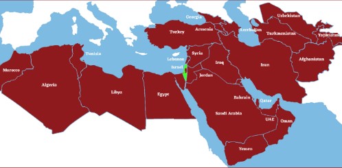
Since 1948, Israel has been attacked by various neighbors in nearly a dozen major wars and conflicts. It has been invaded by armies, rocketed from adjacent states, and assaulted by waves of terror.
Israel has attempted to make peace, but most of the Arab and Muslim world rejects the Jewish people’s right to self-determination in their indigenous homeland.
All nations have the right to live in peace and security – including Israel.

Read: The Mendacious Maps of Palestinian “Loss”

